Chapel Next the Green (the history of Twickenham Congregational Church) index page
Twickenham Congregational Church, now Twickenham United Reformed Church, can trace its origins to the registration of Lady Shaw’s school room as a place of worship in December 1835, and has met on the same site ever since.
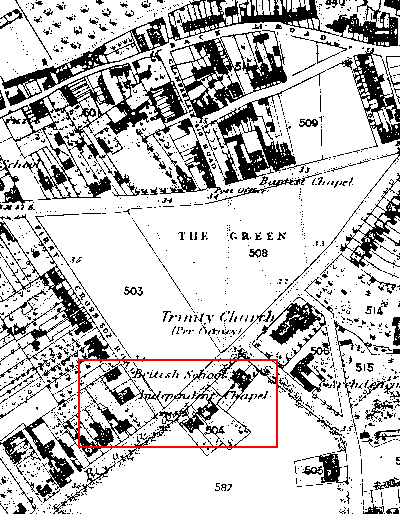
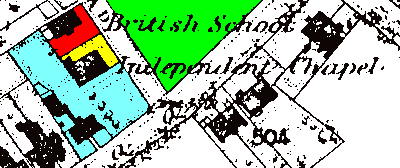
The map above and enlarged extract are taken from the 1863 OS map. The church and hall (linked by the 1866-67 enlargement of the premises) now occupy the red and yellow area. Twickenham Green is on the other side of First Cross Road. The blue area between the church and Hampton Road and to the west of the church site is now occupied by 14 flats, ‘Grace Court’.
At the start of the nineteenth century all this land was part of the 182-acre Twickenham Common, most of which lay between the present Hampton and Staines Roads. From the 1770’s common land was progressively enclosed across the country, and in 1813 an act was passed to enclose the remaining common land in Isleworth, Heston and Twickenham.
Following a survey the land was laid out in plots according to the claims submitted. The 1818 Enclosure Award provided for a number of public roads including the Hampton Road, the Hanworth and Twickenham Road (now Staines Road) and First, Second and Third Common Roads (now 5th – 3rd Cross Roads respectively). New private roads included Middle Road (Second Cross Road) and Workhouse Road (now First Cross Road). The last mentioned took its name from the workhouse built to the north of the common in the eighteenth century.
A large plot of land (the areas coloured red, yellow and blue on the map) was allocated to the executors of Robert Lucas decd. who had owned an estate to the south of the common. We do not know what happened next, but when Sir Robert Shaw married Amelia Spencer in 1834 the property was purchased and placed in trust for her. The schoolroom (on the red area) was erected prior to December 1835: note that the plan shows it set well back from the road with what appears to be an entrance porch on the south side. The first chapel was erected on the yellow area in 1843-4 (see the first pastorate). The remaining area was occupied by the Shaw’s house.
The first trust deed for the chapel, dated May 30th 1848, describes the chapel site as being bounded by the “school house and premises belonging to the said Dame Amelia Shaw and commonly called Lady Shaw’s School (and) on the south and west by gardens belonging to the dwelling house in the tenure or occupation of … Dame Amelia Shaw or her servants ...”
Following Lady Shaw’s death in 1860 her executors claimed the money advanced by her for the construction of the chapel. In April 1865 the chapel was mortgaged to Andrew Bowring, a church member who who had a hosier and glover’s business in the City, the trustees being entitled to redeem the mortgage on payment of £596.14.4 plus 5% interest. Kelly’s Directory 1855 lists him as living at The Common, Twickenham, and we know that he was a member of the Church Committee in 1858-60 (and quite probably before and after these dates). The following year eleven new trustees duly paid this sum and the chapel was conveyed to them.
The deed stated “the said purchase money being deemed to be a fair price for the chapel and its land … but the said Andrew Bowring is minded to include the school and premises hereafter described in aid and furtherance of the good object to which the said chapel, school and premises are to be applied ….”. This seems to imply that Andrew Bowring had purchased the school site (which the deed shows as being separated from the chapel site by a fence) in a separate transaction and was now giving it to the church – we are grateful to this day.
As far as the blue area is concerned, by 1894, the date of the OS map above, all the land between the chapel and Hampton Road had been developed, as had the other side of Hampton Road. The frontages along First Cross Road and the first part of Hampton Road were occupied by a number of shops, including a butchers: in 1918 the Church Secretary was instructed to write to the butcher “complaining of driving of cattle and lowing of same during worship on Sunday morning to the great annoyance of the congregation”. The same year legal action was taken against the Acre Steel Company who had fixed their buildings to the church wall without consent. A 1921 minute refers to the bedding factory at the rear of the church being in breach of the agreement made with Acre Steel.
The following extracts from street directories show the occupiers of the Hampton Road buildings up to WW2:
| Hampton road | 2 | 4 | 6 | 8-14 | 16 |
|---|---|---|---|---|---|
| 1865 | W.G.Taylor, Auctioneer and Surveyor (Willow Cottage) | ||||
| 1886 | H.N.Goatly, Butcher | Henry Bush, Grocer | Thomas Pasfield, Baker | James Hall, Veterinary Surgeon (Willow Cottage) | |
| 1891 | H.N.Goatly, Butcher | Henry Bush, Grocer | Thomas Pasfield, Baker | James Hall, Veterinary Surgeon (Willow Cottage) | |
| 1896 | Arthur Nalson, Butcher | Fredk. Brown, Baker | Lansley & Ewin, Veterinary Surgeons (Willow Cottage) | ||
| 1902 | Henry Baker, Butcher | Fredk. Cook, Greengrocer | George Stanford, Baker | Claude Ewin, Veterinary Surgeon (Kempton Lodge) | |
| 1908 | Henry Baker, Butcher | Edward Ellis, Baker | Sear & Son, Bakers | Claude Ewin, Veterinary Surgeon | |
| 1914 | Henry Baker, Butcher | Sear & Son, Bakers | Claude Ewin, Veterinary Surgeon | ||
| 1916 | Walter Glennie, Butcher | Nellie Stubbs, Wardrobe Dealer | Sear & Son, Bakers | Claude Ewin, Veterinary Surgeon | |
| 1920 | Walter Glennie, Butcher | Albert Aslon, Baker | James Pearce, Bedding Mfrs (8-10) | ||
| 1926 | Chas Jeffries, Butcher | C.J.Lang & Co. Electrical Engineers | James Pearce, Bedding Mfrs (8-10) | ||
| 1929 | Chas Jeffries, Butcher | Edwin Buxton, Confectioner | Strawberry Hill Garage Ltd (8-14) | ||
| 1930 | Chas Jeffries, Butcher | ‘Florence’ Ladies’ Outfitters | Edwin Buxton, Confectioner | Strawberry Hill Garage Ltd (8-14) | |
| 1931 | Chas Jeffries, Butcher | ‘Florence’ Ladies’ Outfitters | T.D.Wingfield, Confectioner | Strawberry Hill Garage Ltd (8-14) | Donelan & Warner, Boot Repairers |
| 1932 | Chas Jeffries, Butcher | ‘Florence’ Ladies’ Outfitters | T.D.Wingfield, Confectioner | CR Autos Limited, Garage (8-14) | Donelan & Warner, Boot Repairers |
| 1934 | Chas Jeffries, Butcher | ‘Florence’ Ladies’ Outfitters | Aug. Wood & Jas. East, Confectioners | Knights Autos Limited (8-14) | Babette Gowns |
| 1939 | Chas Jeffries, Butcher | ‘Florence’ Ladies’ Outfitters | Lilian Folley, Newsagent, Confectioner & Library | Hardie’s Garage Limited (8-14) |
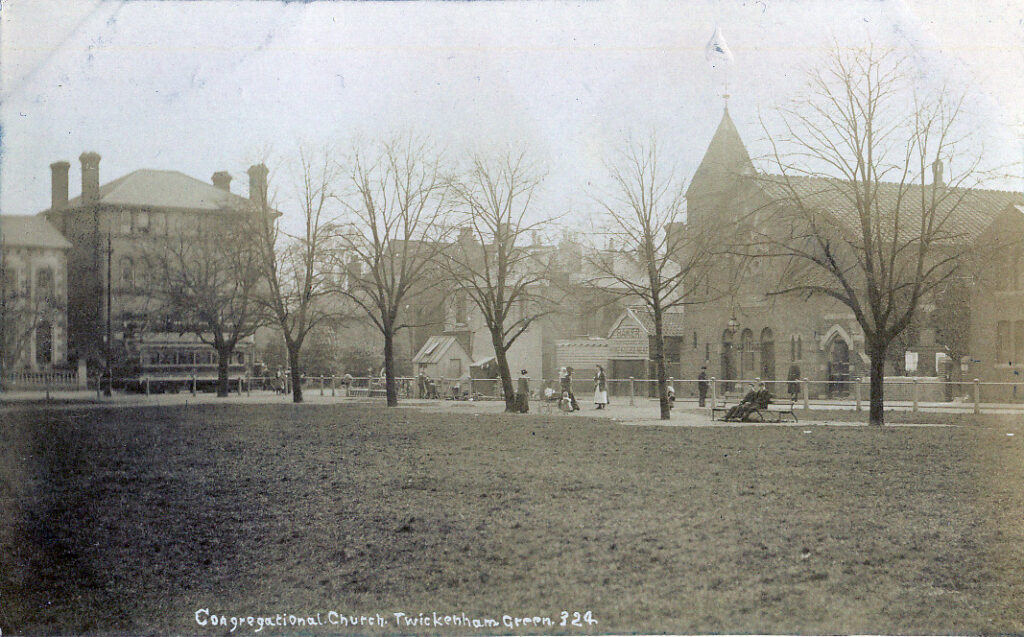
This picture (contributed by local architect, Anthony Beckles Willson) shows the Hampton Road frontage and the original house is still clearly discernable. The name ‘Strawberry Hill Garage’ dates the picture at around 1930.
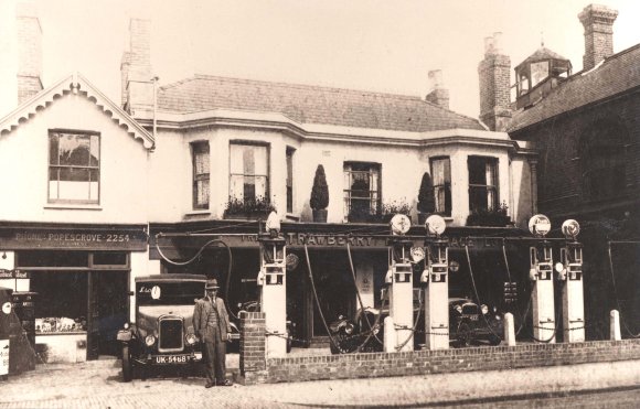
These buildings were later demolished, being replaced by a car showroom. The Hampton Road frontage was rebuilt as an Esso service station in the mid-1960’s.
The buildings along First Cross Road (seen above c.1983) gradually fell into disuse.
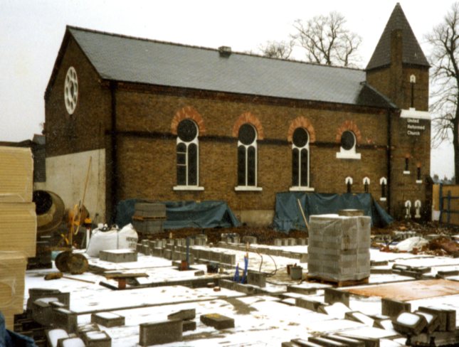
The service station closed in 1994 and after a period during which the buildings gradually became derelict, St George plc erected the 14-flat development, Grace Court, in 1996. Demolition of the old buildings opened up the view of the chapel above that is not likely to be seen again this century. At the time the new flats were built we suggested that they should be called Shaw Court to mark the site’s history but this was not acceptable as another block in the area already had a similar name. The name Grace Court alludes to the fact that W.G.Grace occasionally took part in in charity cricket matches on Twickenham Green
See: Twickenham in 1818: The year of the Enclosure’ – T.H.R. Cashmore, Twickenham Local History Society 1977